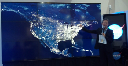
I attended a NASA HyperWall Event which focused on earth’s observation satellites!  There are many many things scientists can take and learn from the satellite’s data and pictures.  They can put composite pictures together to see all of earth at night with the lights reflecting back, which is one of the best ways to illustrate human geography. 

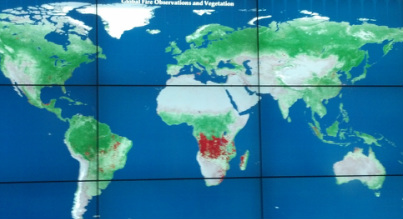
 Also, the satellites can measure clouds, storms, and, temperatures as well as events such as the destruction of forests by natural occurrences, such as wildfires, and by humans through deforestation (the 1988 yellow stone fire was captured by the satellites). At the talk there was one screen of forest fires that was taken through the satellites thermal sensor.  It could be seen that during different season there were more fires than others, most likely due to farming practices and lightening. 

As well they can track the ice at the poles.  There were pictures of the Arctic ice and Antarctic ice shelf showing the fluctuations overtime and the overall decrease of the area of ice.  These areas are hard for humans to get to and monitor themselves so satellites are very useful and full of valuable data that we 
otherwise would not be able to get.  For example, because of the satellites we know that 99% of America’s glaciers are shrinking.  
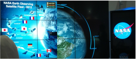
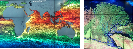
There have been satellites tasking imagery since 1972.  They are meant to last 5 years and cost around 9 hundred million dollars!  Not only can these machines monitor and take valuable data they can also capture amazing photographs of the Earth. (Temperature of the surface of the ocean left and Siberian River Delta right).

Dan Yeager
12/6/2012 06:43:43 am

Thanks for the share! It is amazing how our current technology makes such a massive amount of important data so easy to track and look at.

Reply
Kendall
12/7/2012 03:52:03 am

Hi, I'm a student at York Suburban high school and I just had a question for you! If you had the power to make the first step and get ride of all of the carbon dioxide, what do you think you would do first? And why?

Reply
Jess Bases
12/8/2012 12:44:49 pm

I think it's important that these pictures are being taken and shared. It will provide visual proof to support the affect humans are having on the climate. It shows a comparison in different areas where life is conducted differently and can be used comparatively. In my opinion it will no doubt spread awareness.

Reply
Kate Penrod
12/9/2012 10:38:39 pm

I think things like this are so interesting! It's insane to think about how technology has improved science throughout the years. It has made further valuable research possible. Also, I believe that images like this are more understandable for the general population. For example, I've shown my family (who have no scientific knowledge regarding climate change) research such as the Keeling Curve, which is monumental in climate change education. They were not immediately able to see its importance, and it took quite a bit of explaining before the concept was elucidated. However, images such as the ones that Marla has posted here are pretty easily understood, even by the nonscientific population, which is crucial from the education aspect. Overall, this technology could be highly beneficial, and gives me hope for the future.

Reply
Maggie
12/16/2012 11:52:25 am

Wow! Some of these images are really beautiful -- the Siberian River Delta especially. It's so important that we get this kind of wider perspective of our planet and the ways in which we are altering it on a global scale. There's a tendency for people to look at climate change and other problems on an individual or nationalistic level, but this type of imaging makes it very clear that what we do in one part of the world will invariably affect another. Very interesting to see the weather imaging, too -- I wonder if this is the sort of satellite information that our everyday forecasts use?

Reply


Leave a Reply.